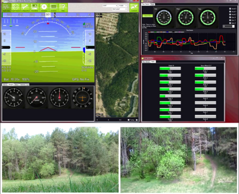
Most of the quadcopter projects that we’ve seen use a joystick-based control system. This lets you fly the thing around like any RC vehicle. But [Saulius] is augmenting his control system by pulling and displaying telemetry data. It doesn’t really change the way the vehicle is controller, but it lets the craft roam much further away because the operator can watch the computer screen and forego the need for the quadcopter to be within sight.
A Carambola board (also used in this weather station project) is used to provide connectivity. This is WiFi based, which helps us understand the range it can travel. The quadcopter carries a camera, which is shown in the lower right box of the image above. There is also an artificial horizon, and feedback dials which display the telemetry data.
It looks like there’s a satellite view in between those two dashboard widgets. We don’t see anything coming up right now, but it’s possible this is meant to overlay a virtual marker for the aircraft’s position based on GPS data. That last part is really just conjecture though. Catch the 80-second test flight after the jump.
http://www.youtube.com/watch?v=_qg779v5GTA


Sure it’s possible to overlay GPS position on a map, many quadcopter users already use remote telemetry using XBee units (some of which have up to 3km/2mile range). We use the QGroundControl Software and the MAVLink protocol for this, which are open source: http://www.youtube.com/watch?v=jQw1Sw1NWXU&feature=player_embedded http://www.universalair.co.uk/fly/rofl#gcs This can be used to set waypoints for autonomous flying.
This whole thing is collectively known as Ground Control Systems, and there are plenty of solutions out there. Saulius’s solution is neat in the use of the Arducopter GCS, and really I think the Hackaday summary should focus more on the merits of using the Carambola WiFi modules than the fact that GCS software exists.
But by using wifi wouldn’t this have terrible range…
The description is hilariously misleading. All the work here was done by Arducopter. It is literally the out-of-the-box mission planner UI. The only “hack” is using more expensive and shorter-range wifi unit instead of a conventional RF modem.
The Control Display looks amazing professional. Yet, the only part I watched constantly was the lower right corner with the live-cam. All those bar that jump around and the tacho on the left thats jumps for a second to one position and then to another… I doint know. I guess I’m more like a after sight pilot.
A tutorial on GCS for all types of ROV’s would make a great piece of content and a nice resource for anyone implementing sensor data in a GUI.
Every thing you see here is available at DIY Drones.
Dear FCC,
Please allow us to build and test stuff like this before the rest of the world runs laps around us.
Thanks,
USA
meh, FCC, FAA… samething
This article was more concentrated in media used to communicate with drone, not telemetry itself. Telemetry was written by arducopter team. And I have used http://www.8devices.com/product/3/carambola/specs board to have link from Ground station to Quadcopter.
Very cool stuff and not that hard to make yourself. Although, don’t see the practical reason for wifi really.